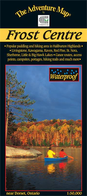

Description
Chrismar #: AM0230, ISBN: 0-929140-23-0, Scale: 1:50,000. Waterproof.
This popular map showcases over 500 km2 of wilderness in the Haliburton Highlands region of Ontario, including the popular 200 km2 tract of crown land known as the Leslie Frost Centre lands.
A great destination for paddlers and backpackers alike, this map covers stretches from Livingstone and Fletcher lakes in the north, to Halls Lake in the south and from Lake of Bays to the west to Kennisis and Kimball lakes in the east.
This completely original map (we make our maps from scratch, just like the government did when making its topo series, only we have chosen a much higher higher standard) features extraordinary topographic and water details, as well as access points, hiking trails, campsites, portages, facilities and other attractions. The back side is covered with colour photos and lots of information about natural & human history, suggested routes, safety tips, contact information and much more.
Following Chrismar’s popularization of this area over 20 years ago with their first Frost Centre & Area Adventure Map®, the local municipality has now implemented a revenue-capturing user-pay system for overnight visits (day-use is free). Our most recent version includes campsite numbers, day-use and group sites, camper and tent limits by site, and other useful information about recent developments.
–––––
This map overlaps to the north with the Oxtongue River/Ragged Falls map, and to the east with the Algonquin 3-Corridor South map